
In a prior post, I laid out the dangers of combined ice, snow and storm surge flooding. It is a potentially catastrophic risk, as exemplified by the Blizzard of ’78 in New England. But fortunately, it’s very rare and perhaps unprecedented at the New York City area to have a combined severe snow and coastal flood event. This is likely just due to the low probabilities of multiple “bad luck” coincidences coming at one time (winds of the right direction, the right speed, a slow-moving storm system, large tides, a moisture source, and temperatures needed for heavy snow).
While the wind will be dangerous and snow is likely to be severe (18-24″ is presently forecast) and potentially even historic, fortunately there are several signs that this will not be more than a minor flooding event in the New York City metropolitan area. For one thing, the surge is very unlikely to be more than 3 feet, and for most locations, more like 1.5-2 feet. The tides are not large, running about 4.5 feet at New York Harbor (Battery tide gauge). And the winds are predicted to be from the northeast today, but at the worst of the storm they will rotate and come out of the north, whereas our worst flood events are more of a northeast to southeast wind direction. And lastly, while the storm is going to move slowly, it won’t move slowly enough to build up a large surge — the surge should only build for about a day maximum, in contrast to Hurricane Sandy’s surge which built up for three days.
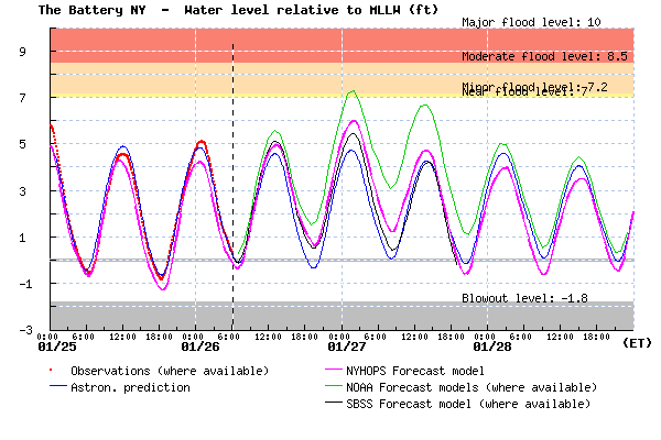
Coastal flood forecast for New York Harbor in feet above mean lower low water (average daily low tide). In addition to the astronomical tide prediction, three forecasts are shown. The Stevens forecast is the magenta line.
Currently, our forecast with our Storm Surge Warning System is predicting only 1.5 feet of storm surge, on top of a moderate high tide, so no major flooding problems for the New York Harbor area (some flooding may occur at places that flood multiple times every year).
The difference between forecast models is somewhat interesting for western Long Island Sound, at Kings Point. NOAA models are forecasting a 3-4 foot surge, whereas Stevens is predicting a 1.5 foot surge. If the NOAA models were correct, again flooding would only occur are areas that see flooding multiple times per year.
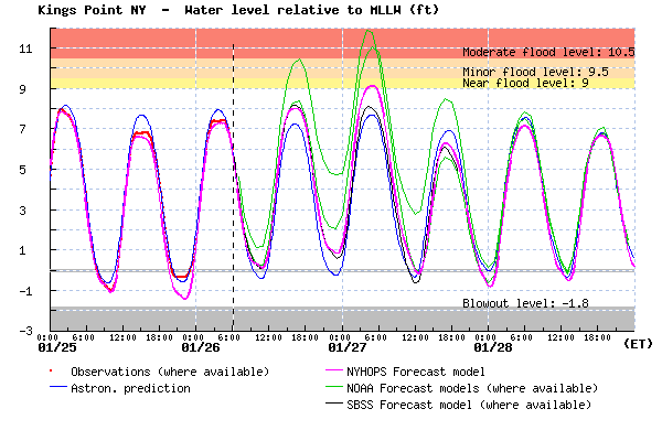
Coastal flood forecast for western Long Island Sound (Kings Point) in feet above mean lower low water (average daily low tide). In addition to the astronomical tide prediction (blue), four forecasts are shown. NOAA forecasts are in green. The Stevens forecast is the magenta line.
Forecast models disagree because the ocean models are different, because the weather models they rely upon are different, and for a host of other reasons. So, we’ve learned that one model is never perfect and having a set of forecasts is useful. So, a cool thing we’re working on with our flood forecasting is to eventually merge many forecasts into one, called ensemble forecasting. While our graphics now show 3-4 forecasts from different groups, we are studying how we can make dozens of forecasts and merge them into one that has an uncertainty represented. A useful way this can be presented is as percentiles — if someone wants to see “worst case” estimates, they will be able to look at the 90th-percentile flood height forecast. If they want the “central estimate” they can look at the median 50th-percentile forecast. Coming soon!
The southern New Jersey coast is likely up for a more dangerous event, as they will bear more of the brunt of the storm, with ~2 to 3 foot storm surges and moderately large waves. The NYHOPS forecast for waves at Atlantic City is 6 feet.
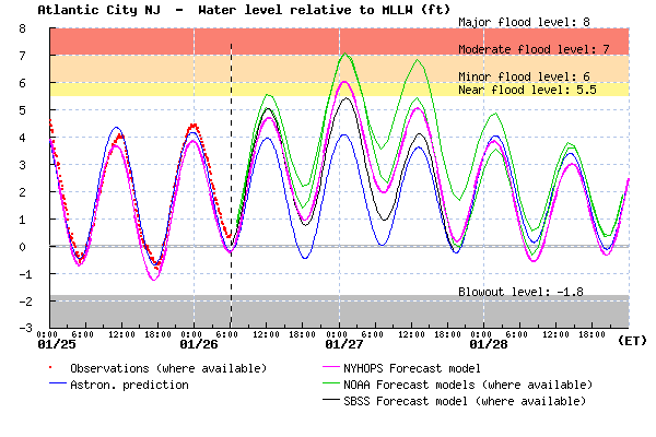
Coastal flood forecast for New York Harbor in feet above mean lower low water (average daily low tide). In addition to the astronomical tide prediction, four forecasts are shown. The Stevens forecast is the magenta line. Large waves and erosion could also be a factor on the Jersey Shore.
Also, parts of New England are also threatened by the very large waves, forecast to be roughly 20 feet! Waves are often an important part of their coastal winter storm risk.
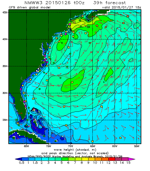
NOAA Wavewatch forecast for the US East Coast at 8:00AM Tuesday (EST), with colored wave heights in meters.
Shorelines of Massachusetts and New Hampshire may be where the largest coastal flood and wave risk is, but again they are lucky it is not a large, spring tide, as occurred during the Blizzard of 1978.

