
A massive extratropical storm over the Midwest will bring strong southeast winds to New York Bight and the potential for widespread coastal flooding this Thursday and Friday. Sustained winds in the New York metro area will peak at 25-35 mph and rainfall will total 1-2 inches. The storm will intensify and sit over the Midwest Thursday and Friday before moving northward Friday so that winds will shift to come from the south and then west, bringing an extremely cold air mass into our area.
The Stevens Flood Advisory System (http://stevens.edu/SFAS) provides forecasts for the NY/NJ Harbor region with detailed coastal ocean and river models and an ensemble of storm data from the US, European and Canadian models. Given the coincidence of spring tides plus storm surge, there is a significant risk of coastal flooding for our region Thursday evening through Friday morning. On Friday morning’s high tide, there is potential for moderate coastal flood thresholds to be exceeded at all harbor regions and even major flood thresholds in the lowest-lying areas. Peak storm surge across the area is predicted to be 2-5 feet within 90% confidence. Central forecasts for peak water levels are forecast to be 5.0 feet NAVD88 for Battery (Figure 1) and 5.6.feet at Jamaica Bay (Figure 2). The near-worst-case scenarios (95th-percentile) are 6.2 feet and 6.7 feet, respectively, a National Weather Service designated “moderate flood” at New York Harbor and “major flood” for Jamaica Bay and some other low-lying areas.
We are normally concerned with nor’easter storms for coastal flooding impacts in our area, but the worst historical cool-season storm surge event came on a continental storm on November 25th 1950. That storm also caused southeast winds, but at speeds approaching hurricane strength. It caused a storm surge of 7.9 feet which peaked near the time of low tide, sparing most areas of severe flooding. During the typical rapid passage of a severe storm (12 hours or less), winds from the southeast have more efficacy in creating a large storm surge in New York Bight.
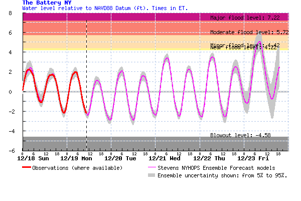
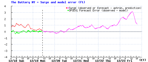
Figure 1: Forecast water levels (top) and storm surge (bottom) at The Battery, Manhattan
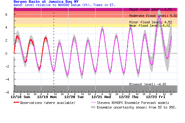
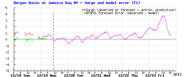
Figure 2: Forecast water levels (top) and storm surge (bottom) at Bergen Basin, Queens (near Kennedy Airport and Howard Beach)

