
Low-lying areas of the NYC Metro area should expect coastal flooding over multiple high tides Friday through Sunday, due to Winter Storm Riley’s winds coinciding with the month’s highest tides. The forecast for coastal areas is significantly worse than for NY/NJ Harbor areas like Manhattan and Hoboken, so I’ll start with comments on these regions. Consult the National Weather Service for official consensus guidance, but here I’ll summarize the picture from my perspective interpreting Stevens SFAS forecasts.
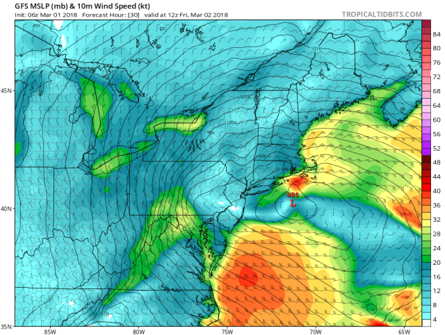
GFS weather model forecast for 7am EST Friday 2 March. Lines show pressure isobars and wind speeds are colored by knots (scale on right). The storm continues to slowly move eastward from Saturday through Monday.
Areas like Keansburg, Sandy Hook and Jamaica Bay are all looking at moderate flooding and the outside chance of “major” coastal flooding.
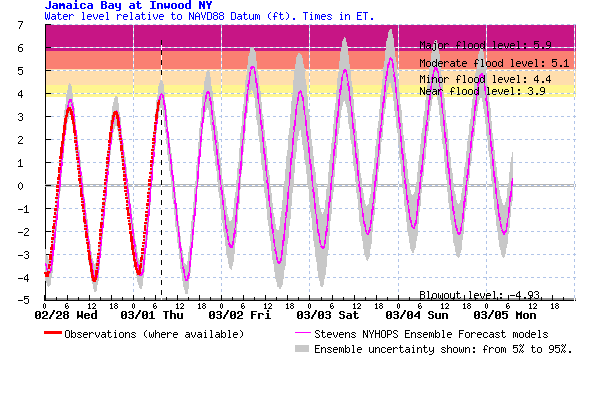
Stevens Flood Advisory System (SFAS) experimental forecast for water levels at Jamaica Bay’s Inwood, New York City (magenta), relative to NAVD88 (similar to mean sea level). Observed water levels are also shown (red dots), as well as 90% confidence intervals (grey shading).
Thus, there is a good chance of low-lying property flooding, and of water blocking streets and becoming trapped for some parts of the Rockaways and all the ‘usual’ locations (eg Broad Channel, Old Howard Beach), Friday through Sunday, peaking multiple times over several tidal cycles. In Jamaica Bay, there is potential for a water level as high as 7 feet navd88, though the central estimate is 5.5 feet (moderately high uncertainty – whether the winds are north or northeast, basically). The highest water level since Sandy was 5.7 feet navd88, and Sandy hit 10.5-11 ft navd88 there, for comparison.
New York /New Jersey Harbor is more likely to see “minor flood” levels, as shown below. The central estimate peak water levels of 5 feet navd88 translate to widespread nuisance flooding of streets and trapped rainfall which won’t drain due to sea levels blocking stormwater drainage. These lower flood elevations in the harbor areas are expected because the winds will often be out of the north, or north-northeast, which is amenable to offshore surge (blame Earth’s rotation!), but actually blows out of NY/NJ Harbor locally. However, there is about a 5% chance of seeing 6 ft navd88, which would become problematic at more locations, though still well below levels needed to cause widespread flooding.
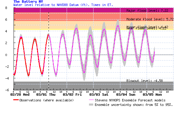
Stevens Flood Advisory System (SFAS) experimental forecast for water levels at Battery Park, New York City (magenta), relative to NAVD88 (similar to mean sea level). Observed water levels are also shown (red dots), as well as 90% confidence intervals (grey shading).
The storm surge continues to roam around the 1-3 foot level all weekend due to the storm tracking offshore and then “bombing out” and sticking around. Winds will continue from the north and northeast all weekend, pumping water into New York Bight and sending large waves toward the New Jersey and Mid-Atlantic coastlines.
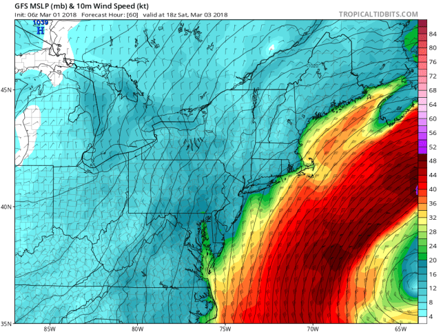
GFS weather model forecast for 1pm EST Saturday 3 March. Lines show pressure isobars and wind speeds are colored by knots (scale on right). The storm continues to slowly move eastward from Saturday through Monday. The storm central pressure is forecast to be 972 mbar at this time, the forecast minimum (by GFS).
Tip of the hat to Nickitas Georgas and Alan Blumberg, now based at Jupiter Intel, who lead creation and development of the Stevens Flood Advisory System. If you value the SFAS flood forecasts, as we all should (they define the state-of-the-art), you might contact them to inquire about the future of the system and its possible funding.

